
Buying a home doesn't lock in its climate risk. The hazard you already knew about usually gets more severe — real events pile up, insurance catches up, and even official maps can shift years later. Checking your address again each year, using Quoll's multi-year event history, catches all of it before it shows up as a bill.
You likely looked at climate and disaster risk once, before you made an offer — and that was the right move. But it was a snapshot, not a subscription. The hazards near a home don't sit still after closing, and neither do the maps and models that define them.
What Actually Changes About My Home's Climate Risk After I Move In?
Usually it's not a new hazard appearing out of nowhere — it's the hazard you already had, getting worse.
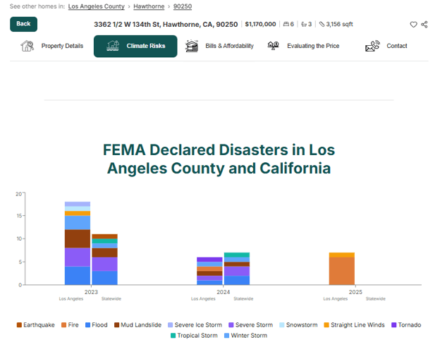
A wildfire-prone hillside doesn't turn into a hurricane-prone coastline in a year. What's checkable is whether events have hit the area since you moved in — a federally declared disaster, a storm, a fire — not an abstract shift in a risk category. Quoll already tracks this at the address level: for any home, it shows the disaster and weather-event history for that area over a multi-year window, not just a risk score frozen at the day you first looked. The clearest recent example of what that record looks like is the January 2025 Los Angeles-area wildfires: across the three hardest-hit communities, the multi-year event history shows very different timelines and recovery paces block by block — exactly the kind of on-the-ground record a one-time pre-purchase check would never surface.
How Does a Worsening Regional Risk Actually Show Up in Your Costs?
Rising severity gets priced into insurance before most homeowners notice the underlying hazard changed at all.
The fastest way accumulating events reach a homeowner isn't the next disaster — it's the renewal notice. What matters is less any single event than how often events are stacking up regionally. The gap between U.S. billion-dollar weather and climate disasters averaged 82 days in the 1980s; over the last decade (2016–2025) it narrowed to about 16 days, per Climate Central's ongoing analysis of NOAA's archived data. Insurers and federal risk maps price in that accumulation, often before residents notice anything changed locally — and that catch-up can trigger new requirements, not just higher premiums. Section 3 below covers a related but distinct mechanism: official maps and designations themselves getting revised, sometimes years apart — a slower speed than the frequency trend above, with its own separate cost consequences. Checking in once a year catches that accumulation before it becomes your bill.
Do the Risk Categories Themselves Ever Change, Not Just Their Severity?
Yes, though more slowly — official flood and hazard maps get re-studied and revised, sometimes a decade or more apart, and a property can move in or out of a designation with nothing physically changing about the home itself.
But designations aren't the only place cost shows up. Separate from the insurance-pricing story above, the underlying effects often reach a household through two faster, non-insurance channels first: utility bills (a colder winter driving up heating costs, a hotter summer driving up cooling costs, or a place that rarely needed air conditioning starting to need it as winters trend milder), and the frequency of home maintenance and repairs as conditions intensify. Knowing this lets you plan for gradually rising costs in your budget, rather than waiting for either your insurer or an official map to confirm what you're already paying for.
The Federal Emergency Management Agency (FEMA) re-studies its flood maps on an ongoing basis, and its 2024 update to South Florida's maps is a clean example of both speeds at once. In Broward County alone, the update moved 88,913 parcels into a high-risk flood zone — and notably, 79,689 of those had been in that same zone before FEMA's 2014 map, were removed at the time, and are now back in it as storm-surge modeling caught up (South Florida Sun Sentinel, June 2024, citing FEMA data). Nothing about those homes changed in the interim; the model re-studying the coastline did. For owners, the practical effect was the same either way: many became newly required to carry flood insurance they didn't need the year before.
Your home's risk picture isn't something you finished at closing — it's something worth a five-minute check once a year. If you haven't checked your home's climate risk since you closed, get started on GetQuoll.com.
Frequently Asked Questions
How often should I check my home's climate risk after buying?
About once a year is enough for most owners — that's roughly the pace at which severity shifts and official map updates tend to surface.
Why does my homeowners insurance keep going up even though nothing happened to my house?
Often because the regional risk around your home got reassessed as more severe, and that gets priced in even without a specific incident at your address.
Does a location's climate risk category ever change, or does it just get worse?
Both happen, at different speeds — severity increases are the more common, faster-moving change; entirely new or removed hazard designations are rarer and tied to official map updates that can take years.
Related reading:
How Do You Check a Property's Climate Risk Before You Make an Offer?
Your First Year as a Homeowner: The Costs Nobody Warned You About — internal link pending, not yet built